


Garmin GTN635Xi SBAS/COM *Experimental Aircraft Info Required*
Garmin International
No Stock. Usually ships within 1 to 2 weeks.
Regular price $13,040.00 $10,500.00 Sale
In accordance with Garmin Aviation Dealer requirements, Experimental Aircraft information must be verified to purchase.
Does NOT come with GA35 Antenna or Datacard.
Includes tray, backplate, connector kit and pilot's guide.
Tap Into a World of Navigation Capability
- Visualizes your entire flight plan, including departures, arrivals, visual/GPS approaches, holding procedures and more
- Overlays potential hazards such as terrain, weather and traffic on a rich, dynamic global moving map for enhanced situational awareness
- Combines an intuitive 4.9” touchscreen with dedicated Direct-to button and dual concentric knob to access information efficiently
- Interfaces with a wide range of existing avionics and autopilots, including our Garmin TXi™ series touchscreen flight displays for an exceptionally integrated and harmonious experience¹
- Optional Connext® cockpit connectivity adds wireless database updates and shares GPS position, weather, traffic and more with your mobile devices and Garmin portables²
- Advanced capabilities optionally available include voice commands, global text/voice calling and much more²
With its centralized, touch-controlled screen providing easy access to navigation, radio tuning, multifunction display features and more, our GTN 635 navigator offers complete GPS/COMM/MFD capability in a robust, single solution. It’s approved for installation in hundreds of makes and models of fixed-wing aircraft and helicopters — putting high-resolution terrain mapping, graphical flight planning, traffic target surveillance, multiple weather options, taxiway diagrams and a host of other advanced navigation features at your fingertips.
To further streamline your cockpit management, GTN 635 integrates with other Garmin avionics to add exclusive industry-leading technologies such as Telligence™ voice command and Connext wireless cockpit connectivity to support data streaming between your avionics and the Garmin Pilot™, ForeFlight and FltPlan Go apps running on your iPad® tablet or another compatible mobile device. Any way you look at it, GTN technology is the logical choice for your avionics stack.
Touch and Go
If you’ve flown with our earlier-generation GNS™ 430 and GNS 530 series avionics, you’ll find the menus of GTN 635 have a familiar layout and feel. But with the GTN 635 touchscreen interface, you’re rarely more than 2 taps away from all of the system’s primary functions. The large, easy-to-use alphanumeric keypad makes data entry a breeze. Pilot-selectable data fields and shortcuts let you quickly reach the information you need to access most. Much like pinch-to-zoom scaling on a smartphone or tablet, you can use your fingers to zoom in and out on any map, traffic and terrain pages. You can quickly pan across the moving map by swiping across the 4.9” high-resolution display or enter waypoint data with the on-screen keypad.
For added control stability in flight, raised grips in the bezel and a shelf across the lower edge of the display serve as gripping points in both smooth and turbulent flight conditions. Traditional concentric knobs are also available for those who prefer that style of data input. If you have a second GTN, GNS 430W or GNS 530W system, pilot-selectable cross-fill capability automatically shares active flight plan information from one system to the other.
Navigate with Ease
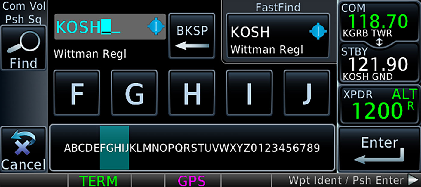
With the GTN 635 system, it’s easier than ever to build and modify your flight plan. As you enter waypoints, our FastFind feature automatically begins searching for the nearest identifier as soon as you start typing — so in most situations a press or two reveals just what you were thinking. The system even lets you load Victor airways and high-altitude jet routes by conveniently displaying the airway segments available from a waypoint and the corresponding exit options. Graphical flight planning capabilities allow you to preview your entire route on the map, and the handy "rubber band" feature lets you grab any leg of your route and move it to accommodate amendments to your flight plan.
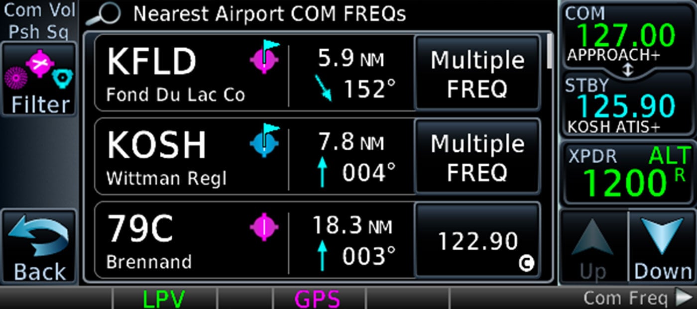
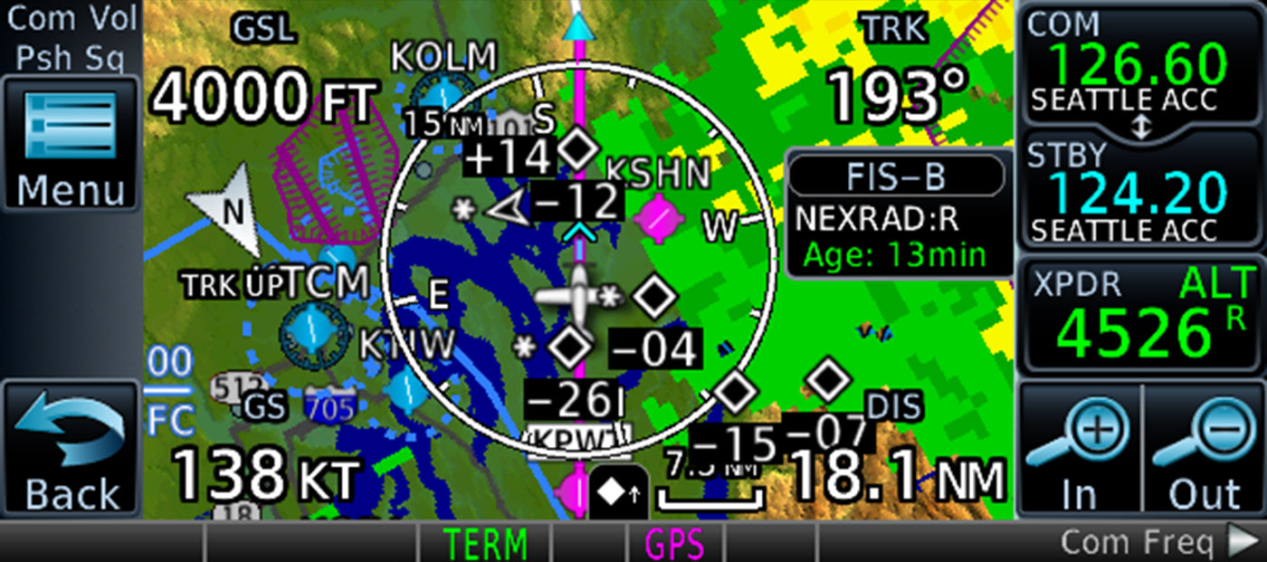
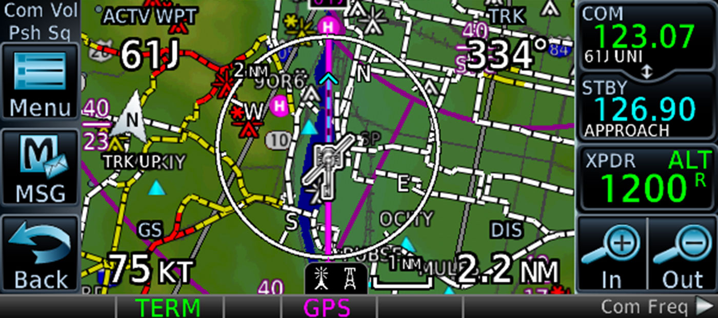
A dedicated Direct-to key on the GTN 635 bezel allows a direct GPS course to be entered for any selected waypoint. It also provides a quick menu of nearest airports and flight plan waypoints for instant entry. With high-resolution terrain mapping — including topography features, cities, airports, terminal areas, SUAs and more, plus optional Class A or B TAWS alerting — you’ll confidently find your way around the sectional-like airspace depiction, with convenient altitude limits right on the moving map. The Smart Airspace™ feature automatically highlights airspace close to your current altitude and de-emphasizes airspace away from the current altitude, while our SafeTaxi® database overlays runways, taxiways, FBOs and hangars on the moving map.
Fly Approaches, Glidepaths, Holding Patterns and More
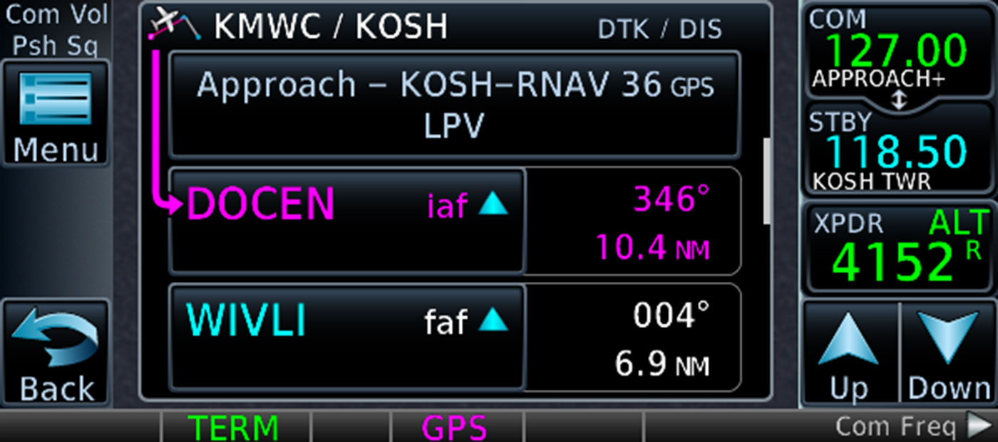
With almost double the GPS approach procedures available in the U.S. compared with ground-based ILS approaches, this SBAS/WAAS-certified GPS receiver can allow you to fly GPS-guided LPV glidepath instrument approaches down to as low as 200’, greatly expanding your operational capability. For added flexibility, you can also select vectors to intercept your final approach course and set up a stabilized approach. Precise course deviation and roll steering outputs can be coupled to Garmin autopilots and select third-party autopilots so IFR flight procedures such as holds, NextGen radius-to-fix (RF) legs and missed approaches may be flown automatically.
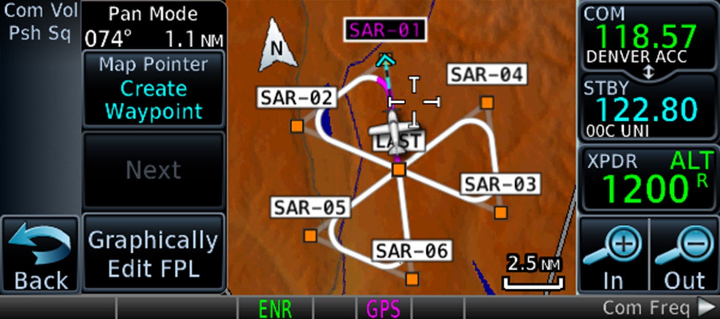
In addition, GTN 635 lets you create and execute custom holding patterns over an existing waypoint or user-defined waypoint. This same technology can simplify search and rescue operations with the optional ability to add common search pattern types into the flight plan. This includes Orbit Search, Parallel Line Search, Expanding Square and Sector Search patterns. When operating in VFR conditions, GTN 635 can also provide advisory vertical approach guidance based on a published glidepath angle or a three-degree approach glideslope from the runway threshold, while considering terrain and obstacle clearance. With this advisory guidance, you’re able to fly more consistent and more precise vertical glidepaths into a variety of airfields.
Make Communication a Breeze
A fully certified VHF communications radio provides a standard 10 watts (or optional 16 watts) of power output. The system is even pilot-selectable to either 25 kHz or 8.33 kHz channel spacing. Recent, nearby and saved frequencies are easy to access. And you'll have added confidence knowing you're talking to the right controller every time with the automatic display of the station’s identifier right below the frequency, for example KIXD ASOS or CHICAGO ACC. As an additional safety feature, holding down the volume knob will automatically dial in the emergency frequency. GTN also automatically decodes a station’s Morse code to provide a positive identification — no aural decoding required.
Add ADS-B Traffic, Weather and More
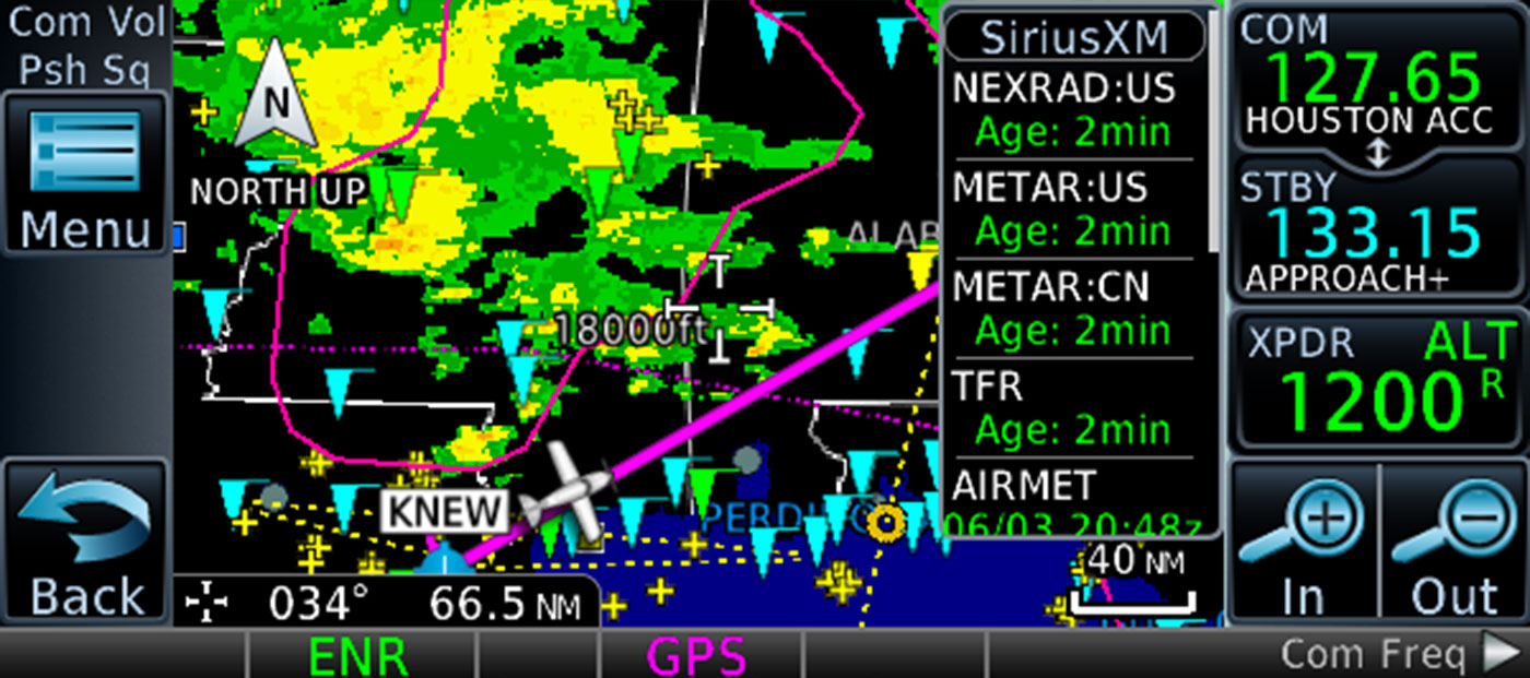
Available dual-link Garmin ADS-B equipage solutions, such as our GTX™ 345 series transponders or GDL® 88 universal access transceivers, allow GTN 635 to display up to 60 ADS-B traffic targets as well as subscription-free ADS-B weather data in the U.S. The ADS-B weather link provides in-flight access to animated NEXRAD imagery, METARs, TAFs, winds and temperatures aloft, PIREPs, NOTAMs and more. On the traffic side, both visual and audio alerts help you recognize and avoid potential conflicts in busy airspace. Our patented TargetTrend™ relative motion technology offers a faster, more intuitive way to judge the direction and closure rate of intruding targets in relation to your aircraft’s position. And for even more advanced traffic surveillance in high-density airspace, GTN 635 can integrate with select TAS or TCAS systems, including our GTS™ family of traffic surveillance products.
At the start or end of each flight, TerminalTraffic™ technology provides the most comprehensive picture of ADS-B-equipped aircraft and ground vehicles in the airport environment. ADS-B-equipped aircraft in-flight are easily distinguished from ground vehicles and taxiing aircraft, which are displayed using distinct colors and symbols. All information is presented on a simple, easy-to-understand SafeTaxi diagram with reference to runways, taxiways, hangar locations and more. Additionally, when configured for helicopter operations, TerminalTraffic helps pilots easily distinguish potential traffic conflicts while in the airport environment by minimizing nuisance alerts from fixed-wing aircraft and abbreviating select alerts while performing unique helicopter maneuvers such as hovering.
Additional Weather and Connectivity Options
You can couple the GTN 635 system with a GDL 69 series datalink receiver to bring even more safety-enhancing (and enjoyment-enhancing) capabilities to your aircraft. With this arrangement, you’re able to receive SiriusXM® satellite weather and audio entertainment3. There’s also an optional GSR 56 receiver that can provide Worldwide Weather data virtually anywhere on the globe, as well as the ability to make and receive phone calls and send and receive text messages while in the air3. To help you better understand weather trends, all of the NEXRAD graphical datalink weather options are animated.
Audio Management with Voice Control
By pairing your GTN 635 with one of our GMA™ 350 series audio panels, you can do even more to enhance and uncomplicate your cockpit communications. With available Bluetooth® wireless connectivity built in, these digital audio systems can be used with your smartphone (or other compatible devices) to make phone calls or stream audio entertainment through your cabin headsets or speakers.
Then, for the crowning touch, our patented Telligence voice control feature enables you to activate key functions by using spoken commands. Intuitively based on phrases pilots commonly use, Telligence accepts hundreds of commands. For example, by simply pressing a push-to-command button on the yoke and saying “Show Flight Plan Page,” GTN will automatically display the flight plan page. Or, when on approach to land, you can simply state “Tune Destination Tower” to load the tower frequency into the standby position. If ATC asks for your distance from the airport, state “Say Distance” to display a pop-up box with distance information, and have GTN read out the number so you can quickly relay that information back to ATC. With Telligence capability you’ll feel as if you have a virtual co-pilot sitting next to you because GTN completes tasks without you taking your hands off the aircraft controls.
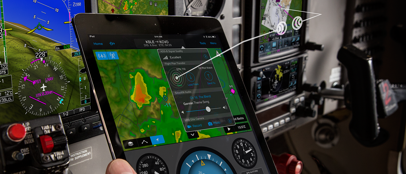
Cockpit Connectivity
For even more work-saving convenience, you can add one of our Flight Stream wireless gateways to your GTN system, allowing you to use our Connext technology to stream information between GTN and compatible Garmin portables or mobile devices running the Garmin Pilot, ForeFlight or FltPlan Go apps. With Flight Stream 210, you can stream information such as ADS-B traffic, weather, GPS data and backup attitude information in real time to your mobile device. In addition to those features, Flight Stream 210 enables flight plan transfer, making it easy to preload flight plans — waypoints, airway routings and all — onto your tablet, smartphone or portable device for quick uploading to your avionics once you’ve arrived at the airport. With an optional GSR 56 datalink, you can even utilize Garmin Pilot to send text messages and initiate satellite phone calls from your aircraft.
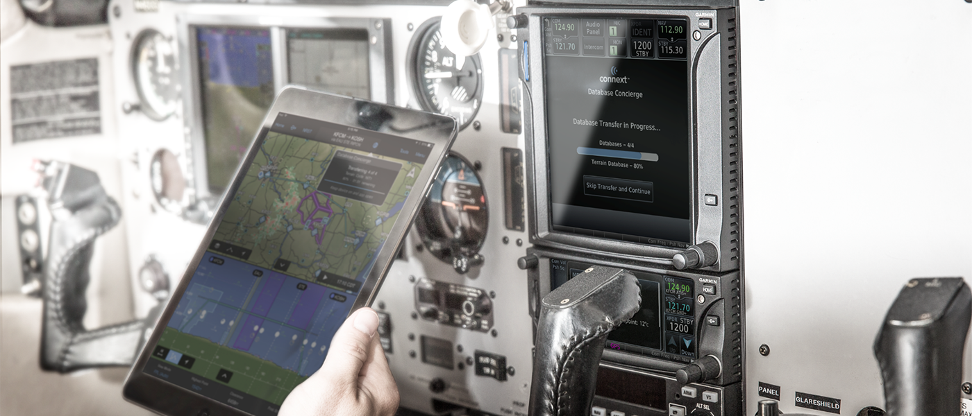
Database Synchronization
For even more capability, you can opt for our Flight Stream 510 to further enhance the Connext experience. This patented multimedia card contains Wi-Fi® and Bluetooth connectivity and installs in the memory card slot of your GTN 635 to provide flight plan transfer, traffic, weather, GPS information and more — plus our Database Concierge database transfer and management capabilities. At home you can download selected databases onto your mobile device, using the Garmin Pilot app. Then, once you get to the airport, Flight Stream 510 will automatically establish a wireless connection to the Garmin Pilot app and upload the databases from your device to your GTN in minutes. GTN then automatically transfers and synchronizes your databases to G500/G600 and TXi series flight displays as well as other GTN systems behind the scenes.
Fly with Helicopter-specific Enhancements
GTN 635 is also available with a number of optional enhancements to help meet the unique demands of helicopter missions. In addition to the already extensive obstacle database used in fixed-wing aircraft, an available helicopter-specific obstacles database features more than 200,000 additional low-altitude obstacles. For added protection, an expanded version of this database features more than 700,000 miles of power lines. This allows for additional visual reference in low-level operations, where our WireAware™ wire-strike avoidance technology uses this database to overlay power lines on the map displays to help pilots recognize potential wire-strike hazards in proximity to the flight path. On the GTN display, each segment of the wire can be touched to instantly reveal both MSL and AGL — and they’re also included in the obstacle alerting so they’ll shade either yellow or red, given your distance to the lines.
Everything From HTAWS to Night Vision
For the ultimate helicopter safety solution, pair GTN 635 with optional HTAWS to provide audible alerting and five-color shading that highlights nearby terrain, obstacles and wires in proximity to your flight patch — as well as voice callouts when descending below 500’. Also, when you’re in the know of potential hazards, you can use our reduced protection and inhibit modes to help keep alerts to a minimum. If you’re using ADS-B “In” to monitor traffic targets in your vicinity, our exclusive On Scene mode helps prevent continued traffic alerting once you’re aware of called-out targets. Plus, when paired with a GRA™ 55 radar altimeter, GTN can be used to display AGL altitude with HTAWS alerting down to 50’. And to support night operations, GTN 635 is optionally available with night vision goggle (NVG) compatibility.
Learn More About GTN 635
With installation approval available for hundreds of aircraft models, adding a GTN system to your cockpit is a straightforward, all-bases-covered proposition. It meets certification requirements for FAR Part 23, 25, 27 and 29 operators and is approved for installation by multiple aviation authorities, including the FAA in the U.S., EASA in Canada, TCCA in Canada and ANAC in Brazil. User familiarization courses are available in person or online, and self-study options are available via our free downloadable PC Trainer or iPad® app. And for worry-free flying, your GTN system comes with an industry-leading 2-year warranty (and optional FlightLevel Extended Warranty), backed by our award-winning product support team. See your authorized Garmin installation center for more information on scheduling a GTN upgrade for your aircraft.
1Reference the supported interfaces tab for compatibility details
2Additional hardware and/or compatible mobile device app required
3Subscription plan(s) required
iPad is a trademark of Apple Inc., registered in the U.S. and other countries.
The Bluetooth word mark and logos are registered trademarks owned by Bluetooth SIG, Inc. and any use of such marks by Garmin is under license. Wi-Fi is a registered trademark of the Wi-Fi Alliance.